5/17: Saying Goodbye

Even as I’m writing this, my time in Hawaii is drawing to a close. Later today, I’ll be back on a plane, en route to the mainland U.S. The two weeks I’ve spent here have been an amazing experience, and instead of focusing on any one particular day or event, I wanted to use my fifth and final blog post to reflect on some of the highlights:

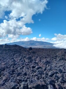
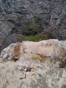
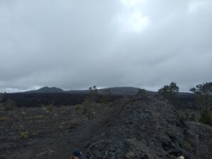
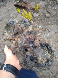
The Geology. I knew very little about the science of geology before taking this class, and being able to see plate tectonics, erosion, and volcanism in action has definitely increased my knowledge of this field. One of my favorite parts about geology is the combination of chaos and order that applies to any geologic formation. Take Chain of Craters Road, for instance. Each individual pit crater—such as Puhimau and Devil’s Throat—formed seemingly at random, with an abrupt drainage of lava that opened a sudden hole in the ground. At the same time, however, the craters are also part of a larger pattern, as shown by the fact that so many formed along a single path: Kilauea’s East Rift Zone. Because of this, geology serves as an important reminder that nothing happens without a reason.

A hand holding a shiny, vesicular rock
A rock. Yay geology!

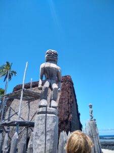
The Culture. The Big Island has a unique culture that dates back centuries, to when Polynesians first colonized the island roughly a thousand years ago. I’ve had the chance to experience only a very small part of Hawaiian lifestyles and legends while I’ve been here, but everything I have seen has intrigued me. Especially interesting are stories about King Kamehameha, the king who united the Hawaiian islands under one leader. Kamehameha is treated with almost religious reverence by many, and the stories of his wise leadership and fierce battle skills are thrilling. In fact, he’s so important to native Hawaiians that there is an entire hotel in Kona named after him; I visited it today and got to see a large exhibit of forty paintings commemorating the king’s legacy.

A wooden tiki statue in front of a temple made of ferns and leaves
A culturally significant statue at Pu’uhonua O Honaunau

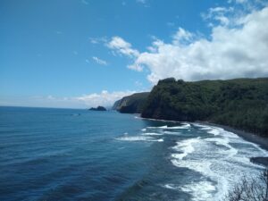
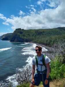
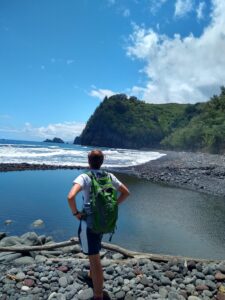
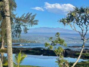
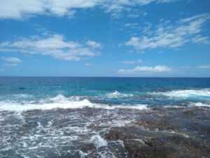
The Ocean. Obviously, a big part of any island is the ocean, which surrounds the island of Hawaii and even influences its volcanic activity. I had never seen the Pacific Ocean before coming here, and I hadn’t been to any ocean at all since elementary school. Every single day, I found myself staring off into the vast expanse of water; it’s still hard for me to comprehend just how far the empty horizon goes, considering that I’m used to being constantly surrounded by mountains. From watching the sun rise and set over the waters to body-surfing waves at the beach, I’ve loved able to connect with the primal force that is the ocean. It’s no wonder that native Hawaiians personified the sea as a deity—Kanaloa.

The ocean.
Ocean

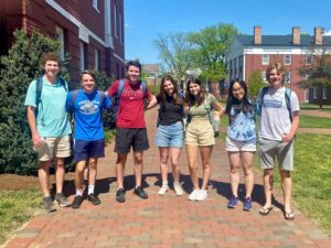
The People. As corny as it sounds, what really made this experience worthwhile were the friends I made along the way. For one thing, I loved getting to meet local Hawaiians; I definitely better understand the spirit of aloha after seeing how friendly and welcoming the island’s residents were to our class. This was especially true of Clegg and Nicole, the amazing older couple from Leilani Estates who welcomed us into their home and made us pizza. Equally important, however, was building relationships with my fellow classmates. Kaden, Caroline, Grace, Margot, HG, Jake, Lucy, Mac, Becca, Abby, and Van are all great people. Whether we were snorkeling in the ocean at Hilo, soaking in the hot tub in Kona, or watching movies in the Cheeky Tiki, it was all a blast. And Professor Knapp and Katie were all excellent teachers who taught me a ton about a field I knew very little about.

Seven young adults standing in a line on the campus of Washington and Lee University
Flashback to before the trip

In closing, mahalo and aloha.

-Aiden

5/15: Valley of the Kings

Today, I walked in the shadow of royalty.

Not literally, but Pololu Valley is one of the seven Valleys of the Kings, meaning it is where the legendary Hawaiian King Kamehameha spent much of his childhood. According to the valley’s caretakers, a prophecy foretold that Kamehameha would become king over all of Hawaii and unite the island under one chief. As a result, many of Hawaii’s chiefs, or ali’i, set out to kill all of the male children at the time of Kamehameha’s birth. However, supporters of the prophecy hid Kamehameha away in the area near Pololu; he sheltered there for the first five years of his life, until the local chiefs accepted the prophecy and allowed him to emerge from hiding. A tall, skinny pine tree marks the exact location of where the future king spent his early days. In addition, the floor of the valley contains Pu’u Ali’i, or the “Hill of the Chiefs” where many old Hawaiian leaders are buried.

A vast, green forest with a tall, skinny pine tree poking up in the middle.
Looking out over Kamehameha’s childhood homeland. See the tall pine tree?

In addition to its deep cultural significance, Pololu Valley contains stunning natural beauty. As I made my way down the technically difficult trail to the valley floor, I got numerous glimpses of the Hawaiian coastline, including the other six valleys, whose greens and browns contrasted strikingly with the clear, blue ocean. Given the lush terrain, it should come as no surprise that Pololu and its neighbors are good agricultural locations. Centuries of native Hawaiians have practiced taro farming in the fertile, well-watered soil. Further adding to the scenic beauty were the sea stacks, which are like mini-mountains just off the Hawaiian coast. Sea stacks are created when waves begin to erode an outcropping of land, then wrap around the back of the little peninsula to completely cut it off from the main island. Erosive forces also influenced the sand of the valley, which is very fine because of heavy wind exposure at the bottom of Pololu.

On the left is a clear, blue ocean. On the right is a coastline of green, lush valleys and white surf.
The Valleys of the Kings, as seen from Pololu

For me, however, the most enjoyable part of the experience was the thrill of racing down (and then up) the steep terrain of the valley. The guides at the beginning of the trail warned us of the dangers of falling or twisting an ankle, but I’m no stranger to technical, rocky climbs, and I loved the thrill of hopping from rock to rock, interrupted only by an occasional pause to talk to friends or snap a photo of the spectacular views.

A young man standing in front of a coastline of green, lush valleys and white surf, with a clear, blue ocean to the left
Pausing to enjoy the view

Unfortunately, the beautiful sights of Pololu Valley were slightly harder to focus on because of the atrocious smell. Our class had the misfortune to visit the location during a dry period in which what must have been thousands of tilapia were trapped in dwindling, brackish pools on the valley floor. Many of these poor fish had already met their demise, leaving the nasty stench of rotting fish as a parting gift. We saw their carcasses washed up on the rocks of the valley, as well as their surviving brethren crammed into the remaining patches of water. Hopefully a major rainstorm will bring some relief to the drying valley floor in the near future.

The hike was also a hot one. By the time I had made it back to the top of the valley, my arms were soaked in a solid layer of sweat, and our class’s water supply had swiftly run out. That made it all the more satisfying when we travelled into a nearby town—called Hawi, I believe—where I ate some delicious, handcrafted strawberry ice cream.

The adventure to Pololu Valley was only one part of an amazing day, but it was certainly the day’s most memorable experience. To see history, geology, and physical activity come together in such a beautiful way was truly remarkable.

A young man wearing a green backpack, standing with his back to the camera. Beyond him is a clear, blue ocean on the left and a green, mountainous area on the right.
Striking a pose on the valley floor

– Aiden

5/11: Farmer’s Market and Saddle Road

I woke up this morning to a pleasant surprise: the sky was clearer than usual, making for a pretty beautiful sunrise. After spending some time on the beach and grabbing breakfast, I set out to get some pictures of Mauna Kea, whose summit was completely visible without any clouds to block it. Walking down the shoreline, I got to see the volcano from a few different angles; I ended up wandering through some weeds, but I ultimately made my way back to the beach house.

Mauna Kea, a massive volcanic mountain, looms in the background. Palm trees and the ocean are in the foreground.
Mauna Kea, seen from the beach near Hilo

For the rest of the morning, we ventured into downtown Hilo for the city’s huge Saturday farmers’ market. The farmers’ market was a vibrant place, with local musicians playing in the streets and rows upon rows of vendors. The oceanside market had everything, from fruits and vegetables to arts and crafts. I tried passionfruit juice—or lilikoi juice, in Hawaiian—and also bought some souvenirs for friends back home. After checking out the vendors, I grabbed lunch at L&L Hawaiian Barbecue, a restaurant suggested by a very wise local (Kaden Buss), and ate with the rest of the class at Liliuokalani Park. A Japanese garden in the middle of Hilo, Liluokalani had some cool Asian architecture and an abundance of endangered Nene geese.

A crowded market, with fruit-covered tables and many customers in the aisleways. Two blue umbrellas and some green crates are prominently visible.
Hilo Farmers’ Market

After lunch, we spent the afternoon driving up the Saddle Road, which runs between Mauna Kea and Mauna Loa. At first, it looked like the experience was going to be a dreary one, and heavy rain plagued most of our drive. However, the foul weather cleared away just as we reached our destination: Pu’u Huluhulu, or the “hairy hill.” The hairy hill is a kipuka, or a hill completely surrounded by lava flows. As a result, kipukas like Pu’u Huluhulu are essentially ecological “islands” that protect native species from foreign hazards. We had to be sure to wipe our shoes before entering the site in order to prevent the spread of invasive plants and diseases. The hairy hill is also a sacred location to native Hawaiians; it is seen as a place where the earth meets the sky, and we saw a statue of a Hawaiian sky god at the hill’s summit. The views from Pu’u Huluhulu were spectacular, and I could see three volcanoes (Mauna Loa, Mauna Kea, and Hualalai) from a single point.

Then, on a whim, we decided to try driving up the Mauna Loa Observatory Road, parts of which were covered by a 2022 lava flow. Professor Knapp thought that the road would be completely closed, but we were actually able to make it all the way up to where the lava had covered the road. This allowed us the chance to walk over relatively fresh (two years old) a’a’ lava. It was sharp! When I took a wrong step, I fell and earned some big scratches on my leg. We also got an even better view of the Mauna Kea summit. Since the region where we were is often rainy, I felt very blessed to be able to see such spectacular sights without much interference from the weather.

-Aiden

In the foreground, a field of rocky, gray, solidified lava sits. In the background, Mauna Kea sits in the midst of some clouds and the bright, blue sky.
Mauna Kea, seen from the 2022 lava field on Mauna Loa

5/9: Chain of Craters Road

After another early morning start, I began the day with a delicious Mac Malambri pancake for breakfast. With that fuel in my stomach, we set off for Hawaii Volcanoes National Park—our second day in a row visiting. Today, however, we went further from Kilauea’s summit to check out Chain of Craters Road, which runs along the volcano’s Southeast Rift Zone and—as the name would suggest—passes by quite a few craters. Though there were far too many for us to see them all, we did take time to observe a couple craters.

First was Puhimau, a large pit crater whose name literally means “forever smoking.” That proved to be true today, and a clear cloud of steam was visible on the far edge. Puhimau’s age is estimated between 200 and 600 years, and it is unique in that unlike many other craters, it has not been filled back in by new lava flows. Instead, a layer of talus, or debris that has fallen from the sides of Puhimau, litters the bottom. Like other pit craters, Puhimau formed very abruptly, giving it extremely steep sides. Unfortunately, this also means that such craters are at a constant risk of collapsing, so we were not allowed to actually go to the crater’s edge. It was still an impressive view, though.

A horizontal view of the Puhimau pit crater. Steep sides of rock dominate the image, with faint steam vents seen at the top.
Puhimau pit crater

We also got to see Devil’s Throat, a “secret” crater that wasn’t formally marked. However, Devil’s Throat was clearly no longer as secret as it used to be, and we did see another group of tourists while we were there. This particular formation is sometimes considered the quintessential pit crater, and it offers a very clear view of both pahoehoe (smooth) and a’a’ (rough) lava flows in cross-section. Seen from the side, the pahoehoe flows were large, gray, and blocky, whereas the hardened a’a’ lava looked fine, red, and bumpy. We also learned that this particular crater was discovered by Thomas Jagger, the namesake of a now-closed geoscience museum at the Kilauea summit.

A view into the Devil's Throat pit crater. A rocky ledge dominates the foreground, with steep walls of rock in the background. A sliver of the crater bottom, covered in rubble, is visible
Devil’s Throat pit crater

After our crater expeditions, we left the national park and made our way down the slope of Kilauea, towards the ocean. Along the way, we stopped for lunch and got a look at another impressive volcanic feature: Maunaulu. Maunaulu is a smaller mountain on the slopes of Kilauea that erupted between 1969 and 1974. Now, the downhill lava flows make a perfect spot for eating sandwiches and watching the Pacific.

A large expanse of gray rock, with two peaks, one of which is Maunaulu, visible in the background. The sky is dark and cloudy.
Maunaulu, on the slopes of Kilauea

Next, we finished our descent to sea level and completed another short hike to see the Pu’uloa Petroglyphs. Situated within an old pahoehoe lava flow, the site at Pu’uloa is a sacred place within Hawaiian culture. Here, generations of Hawaiians have left carved symbols in the flow; many of them were created by inserting the umbilical cords of newborns into the rock. In total, the site includes at least 23,000 petroglyph carvings. I was only able to see a tiny percentage of this amount, but they were certainly interesting. Many of the petroglyphs were circles and spirals, and some were even humanoid shapes. Along the way, I also found a cool new plant: the Showy Rattlebox, which has cylindrical seed pods that make a rattling noise when they dry out.

Our final stop for the day was the Holei Sea Arch, an arch of rock created by the erosive force of the Pacific Ocean. This location was a particularly special visit because of the fact that it won’t be around forever; the sea arch is unstable and could collapse at any moment. Thus, we had to stay far away from the arch itself and could only view Holei from a distance. After taking a few photos there, we headed back to the beach house for some kayaking and snorkeling before dinner.

-Aiden

5/8: Kilauea Iki and Summit

Today, I woke up early to watch the sunrise from Hilo. As we were on the windward side of the island, the weather was cloudy, but thankfully, there were enough gaps in the clouds for a great view. I also took the opportunity to go snorkeling for the first time! It was an amazing experience, and I was able to see a whole array of beautiful fish. In addition to all the aquatic life, I observed an interesting geological phenomenon: ridges in the sand underwater, which I believe are caused by a combination of waves and wind “sorting” the sand into denser and less dense strips.

After a quick breakfast, we made our way to Kilauea Iki, a Kilauea crater that experienced a major eruption in 1959. As we gradually descended into the crater, we learned about the massive eruption, which was more explosive than you might typically expect from an oceanic volcano. According to the visitor’s guide, lava flew as high as 1,900 feet above its source, achieving an all-time Hawaiian record. As with many violent eruptions, the resulting debris piled around the fissure in a cinder cone, known as Pu’upua’i.

The cinder cone Pu'upua'i, a gray, mountainous patch of rock that overlooks a gray desert. The sky bright and blue.
The cinder cone Pu’upua’i

Once we reached the bottom on Kilauea Iki, we found ourselves in the middle of a wasteland. Sheets of black basalt covered the interior of the crater, broken by various cracks and the occasional plant poking up through the rock. During the 1959 eruption, this entire expanse was a lake of molten lava, as evidenced by the “bathtub ring” around the edge, which shows how high the “lake” reached in 1959. Professor Knapp described the way in which lava lakes act as an accurate representation of plate tectonics; as the lava at the top of the lake cools and hardens into solid sheets, the hot lava beneath shifts the basalt in the same way that the mantle moves the Earth’s crust.

The interior of Kilauea Iki, a gray wasteland broken by a few scrub-like plants. The cinder cone towers in the background.
The interior of Kilauea Iki

After a steep hike out of the crater, we walked a short distance to the Thurston Lava Tube, a geological phenomenon that looks like a simple tube of rock but actually has a fascinating backstory. Lava tubes like the Thurston form when the outside of a mass of lava begins to harden. Hot, liquid lava continues to flow through the outer shell, which begins to form a tube-like structure around the molten rock. Eventually, all the lava flows out of the tube, leaving behind a cave like the Thurston. The Thurston Lava Tube was surprisingly short and well lit; I didn’t even need a headlamp, which was surprising.

Next, we drove to the Volcano House, a lodge that looks out over the summit caldera of Mount Kilauea. A caldera is a particularly large crater that forms when the summit of a volcano collapses in on itself. In the midst of Kilauea’s summit is Halema’uma’u, a pit crater that some Hawaiians believe is the home of the volcano goddess Pele. In 2018, Halema’uma’u experienced a massive eruption that broadened and deepened it to multiple times its original size. The newly expanded crater has been the sight of multiple interesting features in recent years, including an unexpected accumulation of noxious water in 2019 and a number of lava lakes. When we visited, however, the crater was quiet, and all we saw was a little bit of smoke.

A broad view of Kilauea's summit caldera. A lush forest sits in the foreground. In the caldera, smoke rises on the right, from the Halema'uma'u pit crater.
Kilauea’s summit caldera

After looking into the caldera, we made a quick visit to the Sulfur Banks. The Sulfur Banks consist of a series of fissures in the ground near Kilauea’s summit. When rain falls into the gaps, it reacts with the sulfur in magma deep beneath the Earth to produce jets of steam. These fractures formed centuries ago, when the volcanoes summit first collapsed to form its caldera. Now, the Sulfur Banks are a source of warm air on a cold and rainy day, as I discovered during my visit. However, there are a number of hazards associated with the site. On one hand, the sulfurous gases of the Banks can obstruct breathing and present problems for those with breathing difficulties. Additionally, the ground near the fissures can be fragile and unstable, as one young guest famously discovered when he broke through the ground and into a scalding hot pit. As a result, I was sure to stay on the stabilized “boardwalk” the whole time, though I did stop to feel the ground near the trail; it was definitely warm!

A fissure at the Sulfur Banks. Mossy ground surrounds a gaping hole, from which a cloud of steam rushes. The background is dull and foggy.
Sulfur Banks fissure

We concluded the day with a few smaller excursions, visiting Hilo’s famous Rainbow Falls and the Boiling Pots section of the Wailuku River. We also got the chance to see Banyon trees, which are fascinating, many-trunked trees that some cultures believe are haunted. However, I just thought that they were pretty and fun to climb on. Finally, back at our beach house in Hilo, I went kayaking for the first time in years.

The rushing water of Rainbow Falls, surrounded by a rich, green jungle.
Rainbow Falls, in Hilo

It was certainly a busy, exhausting day, but I’m so grateful to have been able to see so many natural marvels. I can’t wait to see what the next day holds!

-Aiden