Green Sand Beach? Yes! In South Point Hawaii!

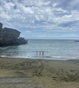
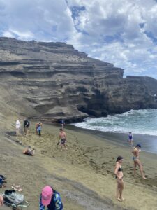
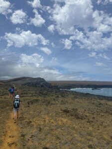
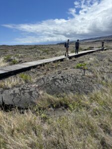
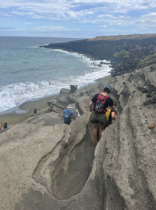
Yesterday, we traveled all the way through the Hawaii Volcanoes National Park down to South Point, the southernmost tip of the United States. Our mission was to see one of the four green sand beaches in the world. The hike, though, was not for the faint of heart and was about 2.8 miles each way. For those less athletically inclined, there were off-roading jeeps that would drive you the way, but our class was up to the task. The journey there was beautiful as we hiked along the coastline and were cooled off by the winds coming off the ocean. We knew we had reached our destination when we saw a large star-wars-spaceship-looking rock with green tints.

Looking out at a large rock at the Green Sand Beach The beach was hidden in a low nook in the rocks that required us to use ladders to descend.

Our group hiking down to the green sand beach

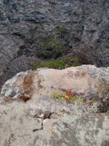
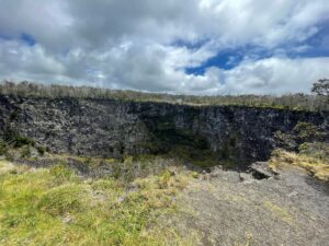
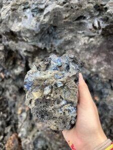
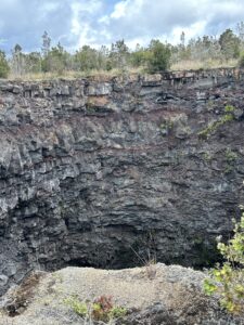
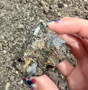
Once we reached the bottom, we worked on an activity to observe the beach’s geology and the reasons for its origin. We began to look closely at the grains of sand using our hand-held magnifying glasses to discover that the green in the sand was due to the olivine. The beach resulted from a cinder cone from the Mona Loa volcano in its southeast rift zone. The green mineral olivine is the first to crystallize when magma cools and is denser than other materials, so it has stayed on the beach. However, the cinder cone is constantly eroding, meaning that the sand will no longer be green one day and that even the whole beach won’t last much longer. We also investigated the layers of rock that we could see from the beach to get a sense of where the olivine was coming from. We saw that the rocks near the ocean were red because of oxidized iron in their composition. We noticed that some rock layers had different textures, colors, and compositions, so we made a stratographic map. After our explorations, we took a little swim in the water. Overall, we had a great experience at the green sand beach and enjoyed our hike!

Looking out the the green sand beach where some of our class is swimming in the water


I Love the Beach!… Especially Green Sand Ones!!

Yesterday was an absolutely incredible beach day! I woke up and headed to the beach right outside our house for a morning snorkel! I spotted a sea turtle and got amazing photos!

Morning rainbow above the beachSea turtle in the rocks Me and the rainbow posing by the beach

We then headed as a class to Papakōlea, the green sand beaches, in South Point. Fun fact… South Point is the southern most point of the United States! After about a 2 ½ hr drive, we hopped out of the van and started a 2.8 mile hike to the beach. Our shoes orange from the sand and the sweat dripping, we ran into the ocean. It was so stunning; the olivine crystals make the sand an olive-green color from the erosion of a now collapsed cinder cone. The rock looks as if a spaceship landed on the beach! After drawing a cross-sectional map of the rock and analyzing the sand and other features of the beach, we packed up to start the 2.8-mile trek back.

Margot posing during our hike to the green sand beachesSide view of the rocket ship esk rock at the green sand beachesMargot and I taking a photo on the top of the green sand beachOlivine pictured in the rock and sand held in Professor’s Knapp hands

After the hard work of the days hiking and researching, we stopped at one more beach, Whittington Beach Park, to change and rest before dinner. This beach was all rock, no sand, which provided great entertainment for walking along the rocky shoreline, taking cute pictures.

Me and Margot posing at Whittington Beach parkMargot and I taking a photo at the beach park

Finally, we ended our night with delicious Shirley temples and Thai food!

Margot and me with our Shirley Temples

5/9: Chain of Craters Road

After another early morning start, I began the day with a delicious Mac Malambri pancake for breakfast. With that fuel in my stomach, we set off for Hawaii Volcanoes National Park—our second day in a row visiting. Today, however, we went further from Kilauea’s summit to check out Chain of Craters Road, which runs along the volcano’s Southeast Rift Zone and—as the name would suggest—passes by quite a few craters. Though there were far too many for us to see them all, we did take time to observe a couple craters.

First was Puhimau, a large pit crater whose name literally means “forever smoking.” That proved to be true today, and a clear cloud of steam was visible on the far edge. Puhimau’s age is estimated between 200 and 600 years, and it is unique in that unlike many other craters, it has not been filled back in by new lava flows. Instead, a layer of talus, or debris that has fallen from the sides of Puhimau, litters the bottom. Like other pit craters, Puhimau formed very abruptly, giving it extremely steep sides. Unfortunately, this also means that such craters are at a constant risk of collapsing, so we were not allowed to actually go to the crater’s edge. It was still an impressive view, though.

A horizontal view of the Puhimau pit crater. Steep sides of rock dominate the image, with faint steam vents seen at the top.
Puhimau pit crater

We also got to see Devil’s Throat, a “secret” crater that wasn’t formally marked. However, Devil’s Throat was clearly no longer as secret as it used to be, and we did see another group of tourists while we were there. This particular formation is sometimes considered the quintessential pit crater, and it offers a very clear view of both pahoehoe (smooth) and a’a’ (rough) lava flows in cross-section. Seen from the side, the pahoehoe flows were large, gray, and blocky, whereas the hardened a’a’ lava looked fine, red, and bumpy. We also learned that this particular crater was discovered by Thomas Jagger, the namesake of a now-closed geoscience museum at the Kilauea summit.

A view into the Devil's Throat pit crater. A rocky ledge dominates the foreground, with steep walls of rock in the background. A sliver of the crater bottom, covered in rubble, is visible
Devil’s Throat pit crater

After our crater expeditions, we left the national park and made our way down the slope of Kilauea, towards the ocean. Along the way, we stopped for lunch and got a look at another impressive volcanic feature: Maunaulu. Maunaulu is a smaller mountain on the slopes of Kilauea that erupted between 1969 and 1974. Now, the downhill lava flows make a perfect spot for eating sandwiches and watching the Pacific.

A large expanse of gray rock, with two peaks, one of which is Maunaulu, visible in the background. The sky is dark and cloudy.
Maunaulu, on the slopes of Kilauea

Next, we finished our descent to sea level and completed another short hike to see the Pu’uloa Petroglyphs. Situated within an old pahoehoe lava flow, the site at Pu’uloa is a sacred place within Hawaiian culture. Here, generations of Hawaiians have left carved symbols in the flow; many of them were created by inserting the umbilical cords of newborns into the rock. In total, the site includes at least 23,000 petroglyph carvings. I was only able to see a tiny percentage of this amount, but they were certainly interesting. Many of the petroglyphs were circles and spirals, and some were even humanoid shapes. Along the way, I also found a cool new plant: the Showy Rattlebox, which has cylindrical seed pods that make a rattling noise when they dry out.

Our final stop for the day was the Holei Sea Arch, an arch of rock created by the erosive force of the Pacific Ocean. This location was a particularly special visit because of the fact that it won’t be around forever; the sea arch is unstable and could collapse at any moment. Thus, we had to stay far away from the arch itself and could only view Holei from a distance. After taking a few photos there, we headed back to the beach house for some kayaking and snorkeling before dinner.

-Aiden

5/10 – Papakōlea Green Sand Beach

Papakōlea Beach might just be my favorite spot so far. Papakōlea Beach is one of two green sand beaches in the United States and one of only four green sand beaches in the world, and Papakōlea in particular has quite a bit higher green sand concentration than these other beaches. The beach is located in a bay cut into a side of Puʻu Mahana. Puʻu Mahana is a cinder cone that was formed during a Mauna Loa eruption on the southwest rift about 50,000 years ago. It. The cinder cone partially collapsed into the ocean and left a crescent shaped tuff-ring. A tuff-ring is a cone with a crater above the ground surface that is not filled with water and has high rims. We started with a beautiful hike over rock along the beach. When we reached our destination, the scene looked like something out of a Star Wars movie. It was gorgeous.

Our walk to Papakolea
Green Sand Beach from top


The tuff-ring that is left is rich in the mineral olivine, and is gradually being eroded. That is what makes the sand all green. Olivine is a silicate mineral with iron and magnesium; it’s one of the first crystals to form when magma cools. Olivine is locally known as “Hawaiian Diamonds” because of its shiny and glassy appearance. It has stayed on the beach because it is heavier than the other components of the lava like ash fragments, glass, and black pyroxene. It is mixed with some black lava and white coral and shell type sand, but this ends up washing away due to the beach’s location in a narrow bay. 

Olivine crystals
Olivine crystals

The cinder cone is constantly eroding, so there is a steady supply of sand right now, but eventually, the beach will look like any other beach. It doesn’t seem like this will be very long because those waves against the rock and sand were intense.

It was really cool to see the different layers in the tuff-ring. Some were more green than others, seeming like there was a higher olivine concentration there, and some were more rocky or fine than others. It looked as if the more rocky layers had less olivine in them. 

I am so glad we got to visit here! 


— HG Kornberg

5/10 – Papakōlea!

Good morning and happy Saturday! Yesterday was such a long day, but it was also incredibly rewarding. We left our airbnb at 9:30 am to head over to South Point, the southernmost point of the entire United States. We stopped for gas on the way and Kaden taught us all about Mauna Pua, a Portuguese sweet bread filled with chop suey pork. It wasn’t my favorite, but I was still pleasantly surprised by it! We then finished the drive down to South Point and parked in the parking lot so we could hike down to Papakōlea, one of only four green sand beaches in the world!

a photo of Mauna Pua, a portuguese sweet bread filled with red chop suey pork Papakōlea green sand beach

It was a 2.8 mile hike to get there, but it was fairly flat and the views were gorgeous the entire way. Once we got there, we ate our sandwiches and dipped our toes in the water before exploring the cliffs on the side of the beach. We looked at the different layers of rock that make up the cliffs and used them to create a stratigraphic column, or a column that shows different rock layers in order to see how the geology of an area has changed over time. It was super cool, and afterwards we were able to swim for a little while before heading back!

On the way back to our airbnb, we stopped for dinner at this place called Thai Thai. I got chicken pad thai, and we all got shirley temples! It was so much fun, but by the time we got back to our airbnb at 8:30 pm, I was so tired that I just took a shower and went right to sleep.

That’s all for yesterday! Thanks for following along!

– Caroline


Day 3: Journey to the end of Chain of Craters Road

By Mac Malambri

Today, I woke in time for the sunrise. Unfortunately, it was cloudy. Despite the clouds, it was still beautiful. My sunrise was followed by making pancakes for the group. I made my beloved chocolate-chip pancakes. I think people appreciated them. We all worked on our blogs, listened to Disney music, and ate pancakes together on a much more relaxing morning than the previous one.

Sunrise rainbow

After breakfast, we had a meeting where we discussed our plans for the next few days. Today, we will return to Hawaiian Volcanos National Park. We will drive further down Chain of Craters Road to see volcanic craters and rock formations along the coast. We then loaded up in the vans and departed.

The drive over was at first identical to the previous day. Once we entered the park, we took a left onto Chain of Craters Road. Chain of Craters Road connects the peak of Kilauea to the coast. Along the way, there are—as the name suggests—many craters. These craters form when some lava solidifies faster than the lava it surrounds. When the hot lava drains away, a deep crater is formed. These craters display the various a’a and pahoehoe lava that flowed over the area. They are very interesting geological features. They are also very unstable and like to collapse. We first went to a large crater along the road with railings and signs and all the things that our tax dollars pay the Department of the Interior to maintain. It was cool. You could see that it was vaguely a crater, but had relatively gradual walls. You couldn’t really differentiate the flow types. The second crater was just a few minutes down the road. In contrast to the very official nature of the first site, there was no parking lot or sign for the Devil’s Throat crater. Professor Knapp only knew about this crater from her work with the USGS. It is around 165 meters deep and 150 meters in diameter. Most people couldn’t really see into the crater; because of the famed instability of the crater, we had to stay about a meter from the edge. I am privileged enough to be tall enough to barely see over the edge if I leaned as far as I could. It was SO deep. I don’t know how to describe it and photos can’t do it. You can see the big blocks of pahoehoe flows and the scratchy a’a flows along the wall of the crater. Professor Knapp told us that the man who introduced her to this crater claimed that it was once a mere 20 meters in diameter and a horse once jumped across it.

Hole Hole Hole

We then headed to the Mauna Ulu, a secondary eruption on Kilauea. It erupted from 1969 to 1974. We stopped there primarily to use the bathroom for the last time for a while. Mauna Ulu looks like a gray ant hill that protrudes from a gray desert with rocks that randomly rises and falls like dunes. Upon further expression, the rocks are not just boring gray rocks, but instead are vesicular rocks with vibrant colors. These rocks display beautiful shades of purple, red, and gold. These rocks tend to have high iron content, given a red tint. They are surprisingly light, because they are vesicular. Vesicular rocks solidify with a lot of gas. The gases form bubbles in rocks. This leaves them porous.

iridescent volcanic rock

Rock

Returning from the rock field, we encountered a gentleman named Tim. He showed us his beautiful necklace. He collected shells on Hawaii for 21 years to create it. It is made of what looks like miniature conch shells. Over eight days, he painstakingly threaded each shell to create this necklace of thousands of shells. We then departed for the end of the Chain of Craters Road. Along the way, we stopped to see the petroglyphs at Pu’u Loa. Traditionally, families would grind the umbilical cords of newborns into the rock.  There, we ventured to see the Hole’i Arch. It was formed by the weathering of the rock by bombardment by waves.

NecklaceBoardwalkMan

Rock Column over foaming waves

We finally departed from the coast and made the long journey back to our house. Everyone was so tired. Caroline made these great burgers and then told us that was her first time making burgers. We finished by watching—but not finishing of course—Moana. This was a great, but exhausting day.

Day 3: Hidden Craters in Volcanoes National Park

After waking up to a breathtaking sunrise and double rainbow, our class made our way to Hawai’i Volcanoes National Park for the second consecutive day. This time, though, we were traveling to the ocean and observing Chain of Craters road.

Our first stop was Puhimau Crater, which means forever smoking and is 400 feet wide, 650 feet long, and 500 feet deep. Puhimau sits between two rift zones and is a pit crater that has formed due to moving magma and the ground above collapsing. Over time, erosion has caused the opening at the top to grow in size until vertical walls were formed around the edges. 

Puhimau Crater in Hawai'i Volcanoes National Park
Puhimau Crater in Hawai’i Volcanoes National Park

Our next stop was another pit crater, except this time it was hidden. Devil’s Throat is not advertised in Hawai’i Volcanoes National park or on the park map, however it is the quintessential pit crater for geologists around the world. Around the crater, you must exercise basic common sense and caution as the edges are unstable and dangerous. Just a short-stroll off the pavement, there is a dirt trail that is not signed or edged by guard rails. Suddenly, there is a 165-foot-deep cavity that sneaks up on you. 

Just like Puhimau, Devil’s Throat is a volcanic pit crater that formed from underground fractures due to moving magma expansion. Devil’s throat was not formally described until 1909 and there is not an apparently historical Native Hawaiian name for Devil’s Throat. The U.S. Geological Survey calls Devil’s Throat “the best, most obvious example of a collapse crater at Kilauea and one of the best in the world”. In recent years, Devil’s Throat has expanded rapidly to over 150 feet across. 

Devil's Throat in Hawai'i Volcanoes National Park
Devil’s Throat in Hawai’i Volcanoes National Park

5/09 – Chain of Craters

Today we got to visit the Chain of Craters in Hawaii Volcanoes National Park!

Originally built in 1928 and modified in 1959, The Chain of Craters Road is 19 miles long. It was partly buried in the 1969 eruption and reopened in 1979. Driving on the road, we were able to see all kinds of lava streams from the past 50 years.

There are seventeen pit craters along the east rift zone of Kilauea that make up the chain of craters. Pit craters are depressions that form as the earth fractures when a volcano shifts or expands. Pit craters are usually oval-shaped and have steep walls. They’re formed from collapse, rather than formed from explosive events like you might assume; we know that they were formed by collapse because if they had they formed by explosion, there would be a lot of debris around. Also, the craters are all fairly young; all of them were created from lava flows that are less than 750 years old. 

We got out and saw a semi-hidden crater, Devil’s Throat. It was so deep! We got to hear about how it used to only be about 20 meters wide. There is some story that says it was so narrow of a split that a horse jumped over it, but now it is clearly much more wide than that. It was super cool to see!

Devil's Throat Pit Crater
Devil’s Throat Pit Crater

We also walked around and took a look at some lava rocks. I loved getting to see the ones that were iridescent and looked rainbow-like. This happens when the lava cools quickly and forms a glassy layer on top of the rock. Super cool!

Iridescent Lava Rock

I loved this stop!


— HG Kornberg

5/09 – Crotalaria

On our visit to see the petroglyphs, we ran into this very interesting plant. It shakes like a rattlesnake when you kick it, and there are pretty yellow flowers that grow on it. After reading about it, I learned that the plant is Crotalaria and is commonly known as Rattlepods! Most of it is in Africa, and it’s believed that it originated in India, but it’s naturalized on several of the Hawaiian islands. 

Crotalaria (Rattlepods)

— HG Kornberg

5/08 – Wailuku River State Park

Yesterday, we took a visit to Wailuku River State Park. While there, we got to see Waianuenue (Rainbow Falls), which was totally gorgeous!

Waianuenue (Rainbow Falls)

We also got to see this incredible and huge, banyan tree. It stretched so wide. We learned from Van that in her culture, these trees hold spirits and are somewhat dangerous. It seems that Hawaiian folklore says something similar. The banyan trees serve as conduits for ancestral spirits but also represent shelter. Very interesting and very beautiful!

Banyan Tree
Banyan Tree

— HG Kornberg