Ka wāwae wāwae

Two days ago was our first full day in Hawaii, and it was quite eventful! 

Our very first stop was at Kadens Uncles property to learn more about Hawaiian culture, and farming. Coffee farming is slowly taking over the macedonia nut farming in Hawaii, and is becoming more and more profitable. I learned about Kona coffee for the first time! 51% of it now has to be from Kona to be dubbed the term, “Kona coffee”. After this, we went over to Kadens farm, and had some absolutely delicious banana bread (that I will never forget). We foraged around for some fruit and veggies, talked with Kadens Mom, pet his dog, and went to our very first geo stop. We also learned that until around 30 years ago, it was illegal to teach the language of Hawaiin to non-natives. 

Dog laying on deck
Kadens dog Blitz laying on his deck


Kaden knocking down an avocado


Caroline holding a fruit at Kadens farm

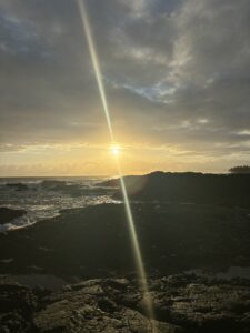
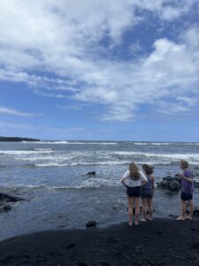
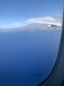
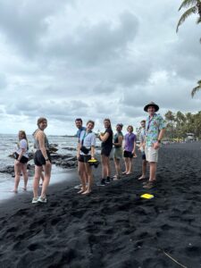
The first stop was in the Punalu’u harbor (close to Ocean View town) to look at the gorgeous black sand beach. On the way to the harbor, we saw the drastic change of landscape that the lava flows would cause. They truly do cut through foliage like a knife! 

Punalu’u literally means, “diving for springs”. We learned earlier in the day that the majority of this side of the islands water come from the rain. Diving for springs is referencing how a lot of the fresh rainwater comes into the salt water. 

Black sand beach
The beach

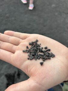
The majority of the volcanic rock here was from the Mauna Loa flows, and is 3,000-5,000 years old. There are a variety of littoral cones in this area, which are cones that erupt near the water. Additionally, the sand here is quite complex. It is made from a variety of materials, such as: hawaiian coral and shells, weathered lava, lava glass, basalts, and olivine. The material is either from submarine or subaerial sources. 

After this, we broke into groups to determine how many grains of sand were on that beach. Utilizing the data we collected on campus (regarding how many meters each one of our strides are), we measured the length and width of the beach, as well as the depth of the sand, and our group estimated that there were 10 trillion grains of sand! 

Van looking at the depth of the beach

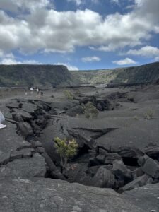
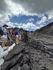
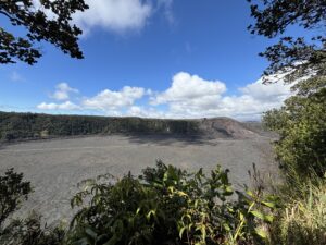
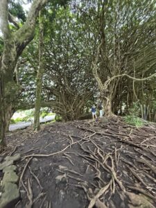
We then departed for our “footprints hike”. To clarify the title, Ka wāwae wāwae means footprints. The Ka’u has a desert-like appearance due to the acid rain from Mauna Loa. The Mauna Loa flows mainly contribute to the volcanic rock in this hike. The a’a flows (more crunchy and chunky flows) and the pahoehoe flows (more smooth) were very obvious on this hike, which was very interesting! The volcanic ash also spread across the entire surface. 

The class surrounding an enclosure of the footprints

There are a few stories behind this footprint hike. But, the main one stems from a battle regarding the heir after the king of Hawaii died. During a battle, it was thought that Kilauea erupted, covering the three battle groups. The footprints in the rock were thought to be theirs. Recently though, the prints were found to be not from warriors, but mostly women and children, and additionally were dated to be before the thought date of the battle. 

Until next time! We are currently all typing up our blogs and eating some delicious chocolate chips that Mac is making!

Day Two: Lava Lakes, Lava Tubes, & Turtles!

Today was the second day in Hawaii, and it definitely was jam packed!

I started off by waking up bright and early at 5:50 in the morning! I walked down to the beach and watched the last part of the sunset, just to see the sun peeking up and a small rainbow forming. Afterwards, I grabbed the snorkel gear and swam around for a while! Although the coral isn’t the brightest, the bright yellow and striped fish definitely made up for it.

Turtle swimming in clear water
Sea turtle in a tidepool!
Bright Hawaii sun rising above the water and rocks
Gorgeous Hawaii sunrise

We eventually made our way back to our Airbnb (which is pretty awesome by the way), and we made some breakfast, hopped in the car, and went to our first stop of the day: Kilauea Iki Lava Lake! We took a decently long hike down to the bottom of the dried up lava lake, listening to Professor Knapps debriefs of around 12 stops. At the bottom, we had the privilege of looking at the lava rock below, and learning about how during the eruption, this lava lake spewed incredibly high in the air, way above the highest landmark in the area, around 580m! The eruption in 1959 was incredibly huge. For scale, 580m tall is as tall as the World Trade Center was. The most recent eruption was not as large, and was in 2018, but the left over water in 2019 proved to be a large concern, as the water increased the possibility for a more explosive eruption.

The deep fissure in the bottom of the lava lake
Varying thickness of the lava rocks!
The class around the same deep fissure
Deep fissure in the lava lake
A picture from the top of the lava lake, of the cavity of black rock and blue sky above
Image from the top of the lava lake

Many natives believe that the volcanic deity, Pele, made this her most spectacular display. The Kilauea calder is known to be the home of this volcano goddess.

Something that was quite interesting was the variety of rock textures below. Although it was all mostly lava rock, due to weathering, and the lava lake drying, there were many different textures present. Weathering from acidic rain (mainly sulfuric acid), rain and wind, and people, caused some of the rock to break up into sand appearing parts. Picking up the sandy parts, one would find tiny rocks, with a texture differing that of a normal beach. Additionally, when looking at the main fissure in the ground, the thickness of the lava rock became quite prevalent to us. When looking at the below pictures, it looks just rocky. But moving across, you can see the true thickness of this rock.

Interesting rock texture at the bottom of the lava lake
Odd texture of lava rock in the lava lake

After this, we made our way back up out of the lava lake, and made our way to the Thurston Lava Tube, which was incredible, and very dark as you can see below! Lava tubes are general passageways that lava travels through, usually under a lava flow. Some are small, like the one Lucy is pointing to in the lava lake, while others are huge! When lava empties from them though, they leave a huge cave! The cave today was pretty dark and moist. After this, we spent some time looking at the caldera of Kilauea, seeing the steam still rising from the floor of it.

Dark tunnel in a lava tube
HUGE lava tube
Lucy pointing to a lava tube in the ground on the lava lake
Mini lava tube in the lava lake

We then left and checked out the volcanos museum and gift store, as well as the art. It is really interesting to look at how prevalent Hawaiian culture is within their art. It is breathtaking.

After this, we took our last volcanic trip of the day to the sulfur banks. When the summit of Kilauea collapsed due to the loss of magma, the caldera was formed. The volcanic gasses under the caldera, ranging from sulfur to other gasses, are then released as steam! The yellow color in the image below is also from the sulfur.

Picture of the sulfur steam!
Sulfur Vents

Going back to the AirBnB in Hilo, we stopped at our first natural stream, and took a peak at what it feeds into: the rainbow waterfall! This was breathtaking, as well as the tree that surrounded it! As seen below, its roots and branches branch everywhere!

Very cool tree in Hilo, with a lot of very spaghetti string appearing branches, and roots going everywhere.
Funky tree!

Getting home, we took another snorkeling trip (as seen below), found some more sea turtles, started on our spaghetti dinner, watched some Teen Beach Movie, and called it a night.

Selfie of the students in the water.
Selfie!

Another our next adventures tomorrow! Stay tuned!

Footprints Hike 👣

My location was Footprints Hike in the Kaʻū Desert….here are some fun facts! 

The Kaʻū Desert isn’t technically a desert because it receives too much rainfall. The dry-looking appearance of Kaʻū is caused by both the acid rain created from gases erupting from Kīlauea and the rain shadow from Mauna Loa. Read more here

The footprints at Footprints Hike have an interesting backstory. Although they are now thought to be the footprints of people going about their daily lives (some are small and thought to be left by women and children), researchers thought two armies left the footprints for a while. That story I will outline below…

Original story behind the prints: In 1782, Kalaniopuʻu, Aliʻi Nui of Hawaiʻi, died. In accordance with his wishes, his son, Kiwala’o, became heir of Hawaiʻi Island. His nephew, Kamehameha, however, had hoped to be named his successor. When he was not, his nephew became upset and launched a campaign to overthrow his cousin, the king’s son. In July 1782, the nephew defeated the son at the Battle of Mokuohai. Unbeknownst to the nephew, some of the son’s family members escaped the battle. Keoua, the son’s half-brother, was one of the warriors who survived. The half-brother returned to his home district of Kaʻu. The half-brother’s uncle, Keawemauhili, was able to escape as well and he returned to his home district of Hilo. For some time, these three leaders kept to themselves not wanting to accept one or the other as paramount chief. Keawemauhili finally decided that he was going to accept the nephew as his aliʻi nui and sent his own sons to assist the nephew in his efforts to gain control of the islands. This decision enraged the half-brother. He decided to take action and thus attacked Hilo, killing his uncle. The death of Keawemauhili, however, was not enough. The half-brother drove the nephew’s army to Hamakua ravaging the lands in his wake. The nephew quickly counterattacked and drove the half-brother back to Hilo. The battle in Hilo not being decisive, both armies retreated, with the half-brother heading back to his home district of Kaʻu. The route to Kaʻu that the half-brother and his troops chose was by way of Kīlauea Volcano. The half-brother and his army started their march to Kaʻu and on the first night camped on Kīlauea near a heiau dedicated to Pele, the fire goddess. This was a period of volcanic activity at Kīlauea caldera. Fearing they had somehow angered Pele, they decided to remain there for several days to bestow offerings in an attempt to appease her. Upon leaving Kīlauea summit, the half-brother split his army into three different companies that left the crater at different intervals. The first company had not gone far when the earth started to tremble violently. Volcanic ash and hot gas exploded out of the caldera. Then, a huge, dense cloud of ash, sand and rocks was ejected out of the crater and rained down for miles around. Unable to escape, all of the individuals in the second party died. One lone pig is said to have survived.Not far behind, the rear-company by chance survived the catastrophe because they were not in the path of the hot ash. Picking themselves up, they continued on their journey determined to get to Kaʻu. They were startled when they came upon members of the second company lying down across the desert floor. When to their surprise, the second company was not resting but in fact lay dead. Discovering this, it is believed that the rear-company choose to move on, not staying to mourn the deaths of their fellow compatriots.The ash, which settled across the desert floor, provided an excellent medium in which footprints have been fossilized. It has been suggested that the footprints are what remains of the half-brother, Keoua’s, fallen warriors. This suggestion was first made by Thomas Jaggar in 1921, but it was purely speculation. Recent archeological and geologic research in the area indicates that the history of the Kaʻu desert may be much more complex and that the footprints may not be from the 1790 eruption but rather may be evidence of everyday life activities in this area. This story was taken from the NPS website, and you can find more information on it here

Background of the footprints discovery: In 1857 a 19 year old tax assessor named Frederick S. Lyman was travelling around Hawaiʻi Island. As part of the tax assessment process, Lyman had to estimate the age of individuals being taxed. Most Hawaiians did not know their ages but could associate their births, in relative terms, with famous “occurrences.” Lyman recorded the information given to him by Native informants and compiled a List of Dates of these famous events. In this list five events were recorded to have occurred in the year 1790. Amongst these events is one buried within the list called Keonehelelei, “the falling sands.” In 1919, when Ruy H. Finch, a geologist at the Hawaiian Volcano Observatory, discovered human footprints fossilized in the Kaʻu desert ash. After they were discovered, a crude trail was marked through the jagged Keamoku flow, and many people visited the area. Soon, this area of the desert, which, in 1919, was not part of the newly formed Hawaiʻi National Park, became known as “Footprints” or the “Footprints area.” You can read more information on the man who discovered the prints on the NPS website here


To close, here are some fun pictures we took on the trail 🙂


picture of a trail and lava rocks on the sides
Trail picture with some lava balls that formed as they rolled through molten lava flows and picked up more and more lava
picture of cooled lava flow desert
Picture taken from the shelter where the footprints are located. The trail continues in this direction.

5/07 – Coffee Farm and Black Sand Beach

Yesterday was our first day exploring the island! 

In the morning, we had the opportunity to visit Kaden’s house around Kona. We got to see what it’s like to grow coffee, and I loved getting to see all the cool plants (like some avocado trees) there!

The coffee plant doesn’t look like I was expecting it to; the plant is very leafy, and the seeds turn colored. Most coffee farmers farm coffee as a side-gig because you need to have a lot of coffee to make good money off of it. To harvest the coffee from the plants, you take the seeds that hold the beans off and store them as “parchment” until there is enough to take to the processor. It sounds like a lot of coffee farmland in Hawaii is being bought by large-scale producers; I hope that Hawaiians are still able to have this type of farming in the future.  

Group exploring Kaden's place
Group exploring Kaden’s place

We also took a visit to Punalu’u beach, one of Hawaii’s black sand beaches. Punalu’u’s sand is made of basalt from lava from Mauna Loa and Kilauea. Upon cooling in the ocean, the lava exploded and broke into tiny pieces. The sand is thousands of years old.

Black sand beach
Black Sand Beach

The beach is home to many sea turtles, and we got to see several while we were there! My favorite part of our visit here was probably when we got to see a turtle be rescued from some fishing line in its mouth and watch it swim back out to sea afterward.

Sea turtle rescue video

While there, we were also on a mission to determine how many grains of sand were on the beach. We measured the length and width of the beach using our pace, estimated the depth, and calculated the volume of the sand in meters cubed. Assuming each grain of sand is 1 mm cubed, we were able to calculate an estimate of how many grains of sand there were. Each of us got a number between a trillion and 16 trillion. That’s a lot of sand!


What a fun day!


— HG Kornberg

Day 1: South of Kona

By Mac Malambri

I will start where I ended yesterday’s post. After departing DEN, we encountered strong turbulence over the Rocky Mountains. I thought it was really fun; most people thought it was a good time to scream. Traversing the rest of the Continent was so cool. I learned a lot just from that. For example, the Rockies are sort of like the Appalachians in that they will have tall mountains followed by long valleys. There are usually at least forest service roads connecting those valleys to civilization. The Sierra Navadas are truly untamed wilderness with insurmountable peaks as far as the eye can see and no signs of civilization at all. You do not realize how vast the Pacific is until you travel over it. From 30,000 ft, it just looks like an empty, light blue surface with nothing: no signs of life or land or anything but water.

We landed by traveling around the front of the main island to the back of it. That gave us an awesome view of the beautiful island. We landed in Kona which is such a cool airport. It is open air and really fits the city. We spent that night in the Holiday Inn Express which was actually really nice. A group of nine of us got dinner that night at a restaurant in town. The fish was pretty good, but the view was better.

View of a volcano

Restaurant of the first night with nine teenagers taking a selfie

The next morning—which is the day this post is about—we awoke and got an early breakfast. A group of us went for a walk around Kona. The community was asleep. Kona is a really cool town. It reminds me of a nicer version of Jaco. It has many restaurants and hotels that like a narrow strip along the beach. After breakfast, we left Kona for Kaden’s neighborhood. Kaden Buss is one of the guys on my trip who happens to be from South Kona. His family has a farm. First, we visited his nearby neighbor with a larger farm. His neighbor told us about how much of Hawaii was given away in a 1940’s era homesteading scheme. He grows coffee and macadamia nuts but is gradually converting all the macadamia nuts to coffee, because the macadamia nut market is really bad right now. He moved to Hawaii from Florida. He said life without air conditioning or running water is different, but he is glad he made the move. We then traveled two minutes to Kaden’s home where his move graciously welcomed us with fresh fruit, banana bread, and Hawaiian soda. Kaden showed us around the farm and explained the process of growing coffee and tea.

We then departed for Punalu’u, home of a black sand beach. Black sand beaches result from the weathering of basalts—black, igneous rocks that form from higher temperature lava that has a lower silica content. Besalts are the predominant mineral on Hawaii, hence the predominance of black sand beaches on Hawaii. Black sand beaches are really different from the white sand beaches we have back home. The sand has much larger and courser grains than our sand back home. It feels soft in your hands. It also was really hot to touch on a cloudy day, so I can’t imagine what it is like on sunny day. As an exercise, we estimated that there are about 9 trillion grains of sand on the quarter mile stretch of beach we were on.

Two guys in front of a road barrier

Nine teenagers measure the number of grains of sand on a beach

Next, we went to the footprints trail. In the 1790s, Mauna Loa erupted so quickly that the people foraging there could not escape. They were covered by the approaching lava and their footprints have been preserved. It was incredible how desolate the lava field was. It was mostly a’a lava, lava that flowed at a lower temperature. The whole scene reminded me of the planet where Anakin Skywalker was burnt alive in Star Wars Episode III. The hike was still cool, though.

Finally, we made the last drive to our rental in Hilo. We have a couple houses, next to each other, across from a beach. We finished the evening with Taco Tuesday and watching Mauna.

Day 0: Travel

By Mac Malambri

I am writing this at Denver International Airport on the plane, preparing to depart. After 11 hours of travel complete—beginning at 3–and with 7.5 left, I am quite tired. Nevertheless, I am excited to begin this adventure.

Over the past week, I am learned the basics of geology. In summary, there are two competing forces involved in earth processes. The tectonic movements create and destroy rock at the conflict zone between plates, while the climate system results in weathering rocks. All of this results in a cycle in which new rocks are created through cooling lava, transformation of other rocks, or compression of small minerals into rocks. They are destroyed by reintroduction into the magma layer or weathering.

Hawaii specifically has created by a hot spot—pool of extra hot magma near the crust. This hot spot causes the geologic processes ini Hawaii despite it’s distance from the boundaries of any plates; it’s in the center of the Pacific plate. The hot spot stays constant, even as the plate moves, which is why there are many Hawaiian islands as well as seamounts northwest of the hotspot.

As for a summary of my travels so far, I awoke at 2:35 AM. I met my class outside Graham-Lees Residence Hall at 3 AM for an early ride to Dulles. It is crazy to see just how quite the Shenandoah Valley is before dawn. Meanwhile, the highways outside of DC are not quiet before dawn. Somehow, we were briefly at a stand still in traffic before 6 AM. Back in Socastee, you could drive all over and only see a couple other cars. Getting into Dulles was mostly smooth with the exception of one girl who’s ID barely differed from her ticket and had to go through an extensive verification process. We had a 2 hour layover in Denver. Even the airport, the beauty of DEN and the Rockies is just incredible. I am now about to depart for Kona. Let the adventure begin!

A view of DEN in front of the Rocky Mountains.