Xenoliths!

Good morning! It’s our last full day here in Hawaii, and I’m writing this from the pool deck at our hotel here in Kona. Yesterday was quite a day, as I was finally able to share my topic with the group – xenoliths!

A xenolith is a rock that is trapped in/a part of another, different rock. It can occasionally be trapped in a sedimentary rock, but usually it’s in an igneous rock (a rock got trapped in magma and then the magma cooled around it). This normally happens when the current from the magma flowing below the earth’s crust is strong enough that a piece of the mantle breaks off and starts flowing with the magma.

The xenoliths we saw yesterday were from Hualālai’s 1800-1801 alkalic lava flows, which are actually famous for their unusually high quantities of xenoliths. We saw lots of olivine, peridotite, pyroxenite, and gabbro xenoliths. Some of them were from the mantle, but most of them were formed by built-up amounts of the minerals that crystallized from the magma before it erupted.

It was super cool to see the xenoliths and share what I had learned with everyone, and afterwards we each did a creative presentation that had something to do with Hawaii. We did a rap song – the lyrics are below – and the other group put on a skit! It was so much fun.

– Caroline

Two xenoliths lyrics to our rap

Pu’uhonua o Honaunau (Place of Refuge)

Hey blog readers!!

Tuesday was our first full day in Kona. Some of us woke up in the early morning to go to a beach that Kaden regularly visits. It was a black sand beach and the water was so crystal clear. It was a great spot for snorkeling and we tried our hand at paddle boarding. It was very hard to stand on the board with the waves, but we all were able to stand for at least a few seconds! 

A group of us paddle boarding

We met the other group at Pu’uhonua o Honaunau. This is a place of refuge originally built in 1650. Hawaii was divided into districts. Kapu were there rules or regulations that Hawaiians needed to follow. For example, women could not eat sacred fruits such as bananas and couldn’t eat in front of men. Men couldn’t look the chief in the eye or walk in his shadow. If the kapu were broken, they were executed. 

The alternative is to flee to one of these places of refuge. This was a safe haven for exiles. They ask for a priest for forgiveness and they enter into the program. Today it is a national historical park. Many native Hawaiians still use Pu’uhonua o Honaunau as a sacred site and site of ceremonies/rituals. 

Hawaiian TikiHawaiian Tiki by the ocean

After eating lunch and trying the avocado from Kaden’s house we headed to Two Step. This is a popular spot for snorkeling. There were lots of urchins and cool fish. We got to see a ginormous parrot fish!

Next, we took a quick stop at Captain Cook’s reserve. In 1789, Captain Cook was the first explorer to find Hawaii.  This was the site of where he landed but also the site of where he died. At first, the native Hawaiians greeted him with kindness because they thought he was a god due to his white complexion. Cook left but damaged the ship’s mast so he returned. The Hawaiians knew that he wasn’t a god and Cook and his crew got aggressive with the Hawaiians. He was killed and now there is a monument in the reserve. 

It was a long day in the sun and being the analytical thinkers we are, we applied layers of sunscreen throughout the day. Very few of us were burnt! (Except for Mac whose whole back was burnt). Overall it was a very fun day!

-Becca Goldman

My Last Blog

Yesterday I got up at 6:50 and went for a walk around Kona. I talked to both of my parents, came back to the hotel to get some breakfast, and then we headed off to our first location. First, we went to Pololu which is one of seven similar locations in the area. On Kohala, this beautiful place was created by erosion and landslides which then created a massive tsunami. What makes this place so special is King Kamehameha grew up here until the age of five. King Kamehameha was prophesized to unite the islands of Hawaii, which he did successfully. There is also a burial ground here which gives this area even more cultural significance. The lush and rainy aspects of this location have given it a beautiful landscape. 

Pololu

The rocks here are quite different than rocks from other volcanoes. For example, there are rocks with white crystals which means it is a sodium-rich feldspar. There are more alkaline basalts and this is because of Kohalas later stage volcanism. This is a black sand beach with a lot of olivine. The sand is super fine and this is because of the wind and ocean. We hiked down this beautiful area and it was a 500ft descent in 0.5 miles. We got to the bottom and were presented with a gorgeous landscape. After this, we hiked back up the mountain and I was huffing and puffing at the end of this one. 

Hike down Pololu

Aiden and I and the bottom of Pololu

We then went to lunch and did a review of what we had done so far on the island. After this, we went into a cute small town. We then tried to go to a beach but it was closed because of dangerous conditions. To make up for this we went to see the xenoliths. This is a rock that is a part of another rock from the earth’s mantle (usually an indigenous rock). The rock got trapped in the magma and was broken off and ended up at our location because of the 1800 alkalic flows. These rocks were very olivine-rich. After this, we went back to the hotel and got in the hot tub, showered, and went to dinner. I got a really good taco salad and then we got shaved ice. We then headed back to the hotel and got in the hot tub again and went to bed at 10. 

Xenoliths

The Effects of Kilauea

Today was a sleep-in day. I Got up at 7:30 and did absolutely nothing until we left to go and see the lava trees that were created in the 1790 eruption of Kilauea. Trees have a lot of water in them and when the lava hits the trees it evaporates, insulates, and hardens and that is how they are created. It is also possible for the trees to catch fire instead of creating mold. The lava trees can tell you a lot about the eruption. For example, the bark of a tree can tell you what direction the lava is going. We then headed to the Robinson’s house. The Robinsons were a couple that Professor Knapp met at the farmer’s meeting and they invited us to their house to see Fissure 8. Fissure 8 opened up because of the 2018 eruption. This was an amazing opportunity and I was very thankful to them for offering us this opportunity. They even went out of our way to make us pizza and it was some of the best homemade pizza I have ever had. Seeing Fissure 8 was sad because it destroyed 700 homes but also breathtaking to see. After this, we went to Kaimu.

Lava tree

inside lava tree

The Robinsons house

Kamiu is located on the southeast coast of Hawaii. Meaning “gathering of the sea” it was formed in 1990 due to the Kilauea eruption and it was buried under lava and created a black sand beach. This beach is a symbol of rebirth and growth. Destroyed by lava but after some time the area started to be rebuilt and regrow. We then headed to Issac Hale Harbor which used to be a harbor until the 2018 eruption. It is now a new black sand beach and created new hot springs. Near this is Pohoiki which translates to “small hole.” This is also known as Pele’s workshop. This hot spring was formed in a collapsed lava tube and can reach up to 98 degrees Fahrenheit. A few animals like shrimp call this spring their home. It has low oxygen and light levels so there is a lot of bacteria in the spring. Since there are high levels of bacteria people should not enter if they have an open wound. There are both salt and freshwater and this is called anchialine pool. This Greek word translates to “near the sea” and kind of acts like estuaries. This is important for both fish and Hawaiian culture. 

Fissure 8

Kamiu

After this, we came back to the Airbnb until Kaite wanted to go to Rainbow Falls. Since it was raining too much the falls were brown. This is because there is more water in the lake carries more sediments and debris. We then came back to the Airbnb watched Jumonji and got Domino’s pizza for dinner. We then watched a terrible horror that had no actual horror involved and I would not suggest it. I then went to bed at 10.  

5/15: Valley of the Kings

Today, I walked in the shadow of royalty.

Not literally, but Pololu Valley is one of the seven Valleys of the Kings, meaning it is where the legendary Hawaiian King Kamehameha spent much of his childhood. According to the valley’s caretakers, a prophecy foretold that Kamehameha would become king over all of Hawaii and unite the island under one chief. As a result, many of Hawaii’s chiefs, or ali’i, set out to kill all of the male children at the time of Kamehameha’s birth. However, supporters of the prophecy hid Kamehameha away in the area near Pololu; he sheltered there for the first five years of his life, until the local chiefs accepted the prophecy and allowed him to emerge from hiding. A tall, skinny pine tree marks the exact location of where the future king spent his early days. In addition, the floor of the valley contains Pu’u Ali’i, or the “Hill of the Chiefs” where many old Hawaiian leaders are buried.

A vast, green forest with a tall, skinny pine tree poking up in the middle.
Looking out over Kamehameha’s childhood homeland. See the tall pine tree?

In addition to its deep cultural significance, Pololu Valley contains stunning natural beauty. As I made my way down the technically difficult trail to the valley floor, I got numerous glimpses of the Hawaiian coastline, including the other six valleys, whose greens and browns contrasted strikingly with the clear, blue ocean. Given the lush terrain, it should come as no surprise that Pololu and its neighbors are good agricultural locations. Centuries of native Hawaiians have practiced taro farming in the fertile, well-watered soil. Further adding to the scenic beauty were the sea stacks, which are like mini-mountains just off the Hawaiian coast. Sea stacks are created when waves begin to erode an outcropping of land, then wrap around the back of the little peninsula to completely cut it off from the main island. Erosive forces also influenced the sand of the valley, which is very fine because of heavy wind exposure at the bottom of Pololu.

On the left is a clear, blue ocean. On the right is a coastline of green, lush valleys and white surf.
The Valleys of the Kings, as seen from Pololu

For me, however, the most enjoyable part of the experience was the thrill of racing down (and then up) the steep terrain of the valley. The guides at the beginning of the trail warned us of the dangers of falling or twisting an ankle, but I’m no stranger to technical, rocky climbs, and I loved the thrill of hopping from rock to rock, interrupted only by an occasional pause to talk to friends or snap a photo of the spectacular views.

A young man standing in front of a coastline of green, lush valleys and white surf, with a clear, blue ocean to the left
Pausing to enjoy the view

Unfortunately, the beautiful sights of Pololu Valley were slightly harder to focus on because of the atrocious smell. Our class had the misfortune to visit the location during a dry period in which what must have been thousands of tilapia were trapped in dwindling, brackish pools on the valley floor. Many of these poor fish had already met their demise, leaving the nasty stench of rotting fish as a parting gift. We saw their carcasses washed up on the rocks of the valley, as well as their surviving brethren crammed into the remaining patches of water. Hopefully a major rainstorm will bring some relief to the drying valley floor in the near future.

The hike was also a hot one. By the time I had made it back to the top of the valley, my arms were soaked in a solid layer of sweat, and our class’s water supply had swiftly run out. That made it all the more satisfying when we travelled into a nearby town—called Hawi, I believe—where I ate some delicious, handcrafted strawberry ice cream.

The adventure to Pololu Valley was only one part of an amazing day, but it was certainly the day’s most memorable experience. To see history, geology, and physical activity come together in such a beautiful way was truly remarkable.

A young man wearing a green backpack, standing with his back to the camera. Beyond him is a clear, blue ocean on the left and a green, mountainous area on the right.
Striking a pose on the valley floor

– Aiden

A Special Place in My Heart: Pu’uhonua o Honaunau

Ki'i protecting Pu'uhonua o Honaunau

Today we visited a place that holds a special place in my heart, Pu’uhonua o Honaunau, or “place of refuge”. 

Pu’uhonua o Honaunau is a historical park that preserves the site where, up until the early 19th century, Hawaiians who broke Kapu (ancient laws), vanquished and defeated warriors, and noncombatants could seek safety from all wars and punishments. 

Usual Kapu for commoners include looking at a chief, walking in a chiefs footsteps, or touching the chief’s possessions. For women, the laws were stricter, as for example, they could not eat in the presence of a man. However, there were other Kapu, such as harvesting certain fish out of season, stealing, trespassing, and more. 

The penalty for Kapu was execution, as ancient Hawaiians believed if they did not, the village would fall victim to natural disasters such as volcanic eruptions, tsunamis, famine, and more unless the offender reached the Pu’uhonua. 

If an offender reached Honaunau, they would ask for forgiveness from a priest and eventually be granted a  a second life from the gods. All Hawaiians respected and honored the sanctity and mana (power) of the remains of the chiefs at the Pu’uhonua, which gave the area immense power. 

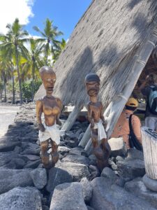
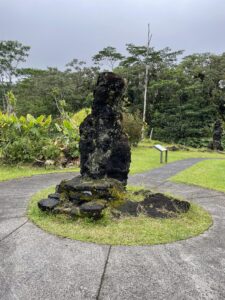
Ki’i or (wooden statues) guard the temple of Hale o Keawe, which was built in 1650. According to ancient Hawaiians, the bones of deceased Ali’i (chiefs) held Mana ( or spiritual power) and burying the chiefs’ bones at Hale o Keawe would protect the Pu’uhonua.  The massive Great Wall marked the boundary between the royal grounds and the Pu’uhonua on the inside.

Honaunau was once a thriving ahupua’a, which stretched from the top of the mountains to the sea, with resources flowing throughout. Honaunau was originally founded in the 13th century; Honaunau was the original seat of the Kona chiefdom and the ancestral home of the Kamehameha dynasty, here in South Kona.  

Each ahupua’a has a Pu’uhonua which  is a sanctuary protected by Lono, the god of life, and considered to be the most sacred place in Hawai’i. The efforts to preserve Pu’uhonua began in the 20th century, with the Great Wall and Hale o Keawe temples restoration when the site became a national historical park in the 1960s. 

Ancient Hawaiian Kahuna (priest-seers) reset the lunar calendar during the Season of the Makahiki Rituals by observing the stars and environment. This period of time (approx Nov – January) is dedicated to the god of Life, Lono, to bring forward a good season of growth. Today, Makahiki is a joyous time to celebrate Hawaiian Traditions (I did this growing up every year), where wrestling and spear throwing matches and games like Moa Pahe’e test skill and accuracy (Sliding darts).

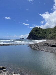
The reason this place holds such a special place in my heart, is because it is where I grew up. I learned to swim, fish, and boat at 2step. I learned basic skills just up the road at Honaunau Elementary, and spent my days at the beach. I even competed annually at Pu’uhonua o Honauanau  in La Pa’ani. As a local school child I competed in annual games and celebrated and learned about Hawaiian tradition! Today, our park ranger was my kindergarten teacher, indicative of my connection to Honaunau.

May 14th: Snorkeling, Puʻuhonua

Today was less eventful (regarding the number of stops) but fun. Some people in our group started the day snorkeling in an area where there was a possibility of swimming with dolphins. I didn’t join because I get to kayak with dolphins regularly during summers for my job, so I figured I’d let others see if they could find any…unfortunately, dolphins did not appear today.

I started the day with a nice breakfast and then moved on with the rest of the group to meet up at Pu’uhonua, a national historic park, which was super cool.

View of the park from the beach...black rocks in foreground, water, and shelter in the back
View of the park from the beach

In ancient Hawaii, this place was known as a “place of refuge.” What that meant was that if a Hawaiian broke what is known as “kapu,” or the rules of the area, they would be put to death unless they could find and take shelter in a place of refuge. These Puʻuhonuas were the home of priests and the bones of chiefs and were considered sacred, so if someone could get to one, they were allowed to claim refuge and live out their second chance at life in the Puʻuhonua. If you want to read more about Puʻuhonuas, click on the link.

thatched roof structure with wood and dried palm roof
Living Structure Model
View of more priest quarters and Tiki structures

Next, the group moved to a snorkeling spot, where we swam around for quite some time. It was really neat snorkeling. We saw a ton of coral and some really bright yellow fish. I was most impressed by the massive sea urchins on the sea floor. They were HUGE. After swimming around for a while, we moved over to a smaller tidal pool warmed by the Sun and sat and talked for a bit, which was really nice.

Some friends posing by the shoreline

After that, we drove to where Captain Cook was killed in the late 1700s. The story we heard from a friend on the trip was that he originally arrived in the islands and was warmly welcomed as a god. The native Hawaiians probably believed he was a god since he had such white skin. Later, when he was leaving, his mast broke, forcing him to return. Upon returning, the natives realized he was, in fact, not a God, and in the face of some disputes between natives and westerners, he ended up on the wrong side of the native Hawaiians, and he was killed in the bay we went to see.

In the evening, a few of us went out to dinner…

three girls with virgin pina coladas
Dinner!

…which was lovely 🙂 we ended the day by gathering and watching Shrek. Mahalo for reading!

“It’s a Beautiful Day”: Mauna Kea and Mauna Loa

As the sun rose on our fifth day of our adventures on the Big Island, we were greeted by a stunning scene of Mauna Kea rising above Hilo Bay. For the first time on our trip, we were greeted by a proper sunrise and clear skies, which allowed us to admire where we were headed later in the day.

But first, we had a relaxing morning to enjoy, beginning with a snorkel expedition with classmates. With low tide our launch and landing  was difficult, but we were able to enjoy high-visibility and beautiful coral reefs.

Then it was time to visit the jewel of town on a Saturday, the Hilo Farmer’s Market. With fresh fruits, vibrant art, and handmade jewelry, the class was able to experience authentic Hawai’i. I was able to snag a few gifts for family and friends, including earrings for mother’s day and eat at a local food hotspot: L&L. 

L&L Downtown Hilo
L&L Downtown Hilo

Finally, it was time to travel up Saddle Road to 6,000 feet in elevation and visit Pu’u Huluhulu. As we began our ascent, we were blanketed in a colossal rain-storm—which the van struggled to get through. As soon as we reached 6,000 feet, the rain passed and we entered a picturesque landscape with sweeping views of Mauna Kea and Mauna Loa.

Mauna Kea from Pu'u Huluhulu Mauna Loa from Pu'u Huluhulu

We began by visiting Pu’u Huluhulu, or hairy hill. Pu’u Huluhuluis a 210 foot tall 400-year-old forested cinder cone right across from the Mauna Kea turn off of Saddle Road. Pu’u Huluhulu is also an important ecological forest for native plants and birds and a sacred Hawaiian site.

After leaving Pu’u Huluhulu, we briefly stopped at the Mauna Kea State Recreation Area for a bathroom break, we decided we would take advantage of the beautiful weather and climb Mauna Loa. The December 2022 eruption of Mauna Loa caused for over one mile of the Mauna Loa access road. The average depth of lava over the road is ~30 feet throughout the flows which begin at 9000 feet in elevation.

Rainbow Falls – again!

This is a bit of a belated post, but the other day while it was raining in Hilo (and had been for about a full 24 hours), a group of us took an impromptu trip back to Rainbow Falls with our TA, Katie, to see how the rain changed the flow of the river. When we got there, it was crazy to see how much faster the water was flowing than it had been the first time we visited. The color of it had also drastically changed – instead of being a greenish blue color, it looked almost like chocolate milk! Katie explained that this is because the faster-moving water picks up a lot more sediments from the riverbed and carries them in the current.

We also got to see an ephemeral stream, which is a stream that only has water flowing through it sometimes, such as when it’s been raining for a while. It was really neat, especially because it hadn’t had any water flowing through it the first time we visited. All in all, even though I got soaked (apparently my raincoat isn’t meant to withstand anything more than a sprinkle), it was a super fun excursion and it was so cool to see how the rain changed the waterfall’s behavior!

– Caroline

seven of us pointing at rainbow falls in the rain

Jungle Time! Akaka Falls, Hamakua Coast, and Waipio Valley

I woke up and finally tried the Hawaiian dish… SPAM! I actually found it delicious. So thank you Kaden for insisting everyone to try some even if Mac didn’t. 

We sadly had to move out of our air B and B. We had amazing time there in Hilo, but we had to move up north along the Hamakua Coast, to Kohala volcano and back around to Kona. 

Lush vegetation and palm trees on hamakua coast
Drive on Hamakua coast

As we drove through up north, this side of the island is older and it the most fertile and lush area on the island. In the 19th and 20th century, it was covered in sugar cane. Today there is still lots of smaller farmers in the area. It such amazing vegetation and rivers as well. We stopped to look at a hot tourist destination, Akaka Falls. This gorgeous waterfall plunges 442 feet into a stream-eroded gorge. Read the Hawaiian legend of the formation of Akaka Falls below.

Akaka falls
Akaka Falls

“The legend of Akaka Falls is quite interesting. In the olden days, there was a warrior chief named ‘Akaka in the village of Honomu. Strong and very handsome, he was famed throughout the island and attracted the eyes of the ladies. One day, while his faithful and trusting wife was visiting her parents in the distant village of Hilo, ‘Akaka went to see his sweetheart on the north side of the gulch.  Her name was Lehua. Seeing his wife return unexpectedly, he left Lehua’s hut by the back door and crossed the gulch to visit his other sweetheart, Maile, who lived on the south side. Following him there because of the scented grass he wore, his wife called for him to return home. Hearing her call him, ‘Akaka hastily sped out the back door and took a shortcut to his home.

Alone at last, ‘Akaka contemplated his ill behavior as he sat in the hut with his loyal dog. Overwhelmed with shame that he could deceive his loving wife, ‘Akaka fled the hut with his dog following closely at his heels. ‘Akaka approached a projecting rock on the top of a bluff.  Looking down to the sea, he then threw himself over the cliff and fell headlong to the far valley below, transformed into the waterfall.

His dog hesitated and was turned immediately into a jagged rock at the top of the falls. His wife, following ‘Akaka closely, rushed through the brush to get to his side. She began to call him, but it was too late. His wife rushed to the edge, and overcome with grief, wept uncontrollably and called for ‘Akaka. It was then that she was transformed into a large rock at the top of the falls. As she wished, she is now permanently there next to ‘Akaka.

The heartbroken sweethearts, Maile and Lehua, upon hearing of ‘Akaka’s death, cried and cried until they too were turned into waterfalls, a little further down the gulch from Akaka Falls. According to Legend of Akaka Falls, this was how the falls came about. Old timers say that on a still and moonless night, when the leaves are quiet and the crickets silent, one can hear, nearly muffled by the roar of the falls, his wife still calling for ‘Akaka.”’

Katie told us the geology behind rivers with her fluvial morphology knowledge. She said this was a knickpoint, which is a break in the river. Three factors could have created it. 

  1. Faulting motion through plate tectonic activity
  2. Lithology: considering the type of rocks and there erosion factors
  3. Climate: base line fluctuations and changes in the lowest elevation river levels

We took another drive to Laupahoehoe, the site of a massive 56 ft tsunami in 1946. It stemmed from an earthquake in the Alaskan islands. We learned how important warning systems are, for there weren’t any back then.

Laupahoehoe park
Laupahoehoe park

We had a final stop in Waipio Valley. This area is more advanced in its erosional stages, which can be seen in its broader valleys. The abrupt cliffs are likely formed from landslides. It’s part of Kohala and named the Valley of the Kings. It was once home to King Kamehameha. His bones actually lie in caves along the cliff side. This has been my favorite area of the island and I can’t wait to return to Kohala to see more of the landscape. 

Waipio Valley with abrupt cliff, black sand beach, and lush vegetation
Waipio Valley

-Becca Goldman