Corrupted Day 10 Post—Hawaii’s Leeward Side: Valley’s, Beaches, Run-off Warnings, and Xenoliths.

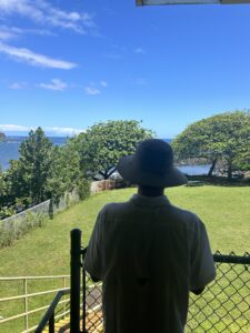
After driving around Hawai’i island, visiting Hawai’i Volcanoes National Park, exploring the Hamakua Coast, and much more, it was finally time for us to visit the busiest part of the island: Kona.  

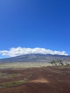
We started our 10th day by driving through North Kona and into Kohala to visit the picturesque Pololu valley. Since Kohala is the oldest volcano on the island, there rocks in Poll are contain more alkaline and have sodium-rich feldspars.

Kaden Buss at Pololu Valley

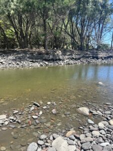
The short, yet steep, hike was accompanied by the simultaneous refreshing yet revolting smells of the Pacific Ocean and rotten fish. Flash floods, just days before we visited, washed tens of thousands of tilapia downstream—which caused the rotting smell—- after large portions of the river dried up. 

Pololu Valley river after severe flooding.
After exerting our energy on the steep hike, we stopped for lunch, and
headed for the famous white sand beach Hapuna. But, there was a catch: For the first-time in my lifetime Hapuna was closed for something other than a high surf advisory. Instead, the Hawai’i Department of Health Clean Water Branch issued a Brown Water Advisory for the waters around North Kohala. This is because Heavy rainfall resulted in stormwater runoff into the ocean. The runoff could possibly contain overflowing cesspools, sewer, manholes, pesticides, animal fecal matter, dead animals, pathogens, and chemicals. 
Mac Malambri enjoying a scenic view at lunch in Kohala

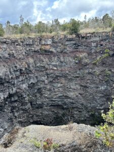
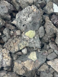
Instead, as we have done the entire trip, our class pivoted. We were adaptable and decided to visit Hualalai Xenoliths. Just along State Highway 190—or as local’s call it, the ‘high road’—there is an impressive collection of Xenoliths with easy access via the road. The 1800-1801 Hualalai alkalic lava flows are famous for their Xenoliths.  These represent the mantle beneath Hawai’i and contains accumulations of olivine, pyroxene, and plagioclase that crystalized from pre-eruption magmas. 

Our class was able to appreciate the Xenolith’s by adding some ‘flare’. We seperated into two different groups: one group reenacting the formation of the Xenoliths and another group creating a catchy rap.

1800-1801 Hualalai Xenoliths.


After appreciating the Xenoliths and touching the mantle of the earth, the class was worn out for the day. Some of us grabbed Poke, others hung out around the pool, and everyone came together at the end of the night to have a nice, students dinner at the beachfront bar, Huggo’s on the Rocks. 

A Special Place in My Heart: Pu’uhonua o Honaunau

Ki'i protecting Pu'uhonua o Honaunau

Today we visited a place that holds a special place in my heart, Pu’uhonua o Honaunau, or “place of refuge”. 

Pu’uhonua o Honaunau is a historical park that preserves the site where, up until the early 19th century, Hawaiians who broke Kapu (ancient laws), vanquished and defeated warriors, and noncombatants could seek safety from all wars and punishments. 

Usual Kapu for commoners include looking at a chief, walking in a chiefs footsteps, or touching the chief’s possessions. For women, the laws were stricter, as for example, they could not eat in the presence of a man. However, there were other Kapu, such as harvesting certain fish out of season, stealing, trespassing, and more. 

The penalty for Kapu was execution, as ancient Hawaiians believed if they did not, the village would fall victim to natural disasters such as volcanic eruptions, tsunamis, famine, and more unless the offender reached the Pu’uhonua. 

If an offender reached Honaunau, they would ask for forgiveness from a priest and eventually be granted a  a second life from the gods. All Hawaiians respected and honored the sanctity and mana (power) of the remains of the chiefs at the Pu’uhonua, which gave the area immense power. 

Ki’i or (wooden statues) guard the temple of Hale o Keawe, which was built in 1650. According to ancient Hawaiians, the bones of deceased Ali’i (chiefs) held Mana ( or spiritual power) and burying the chiefs’ bones at Hale o Keawe would protect the Pu’uhonua.  The massive Great Wall marked the boundary between the royal grounds and the Pu’uhonua on the inside.

Honaunau was once a thriving ahupua’a, which stretched from the top of the mountains to the sea, with resources flowing throughout. Honaunau was originally founded in the 13th century; Honaunau was the original seat of the Kona chiefdom and the ancestral home of the Kamehameha dynasty, here in South Kona.  

Each ahupua’a has a Pu’uhonua which  is a sanctuary protected by Lono, the god of life, and considered to be the most sacred place in Hawai’i. The efforts to preserve Pu’uhonua began in the 20th century, with the Great Wall and Hale o Keawe temples restoration when the site became a national historical park in the 1960s. 

Ancient Hawaiian Kahuna (priest-seers) reset the lunar calendar during the Season of the Makahiki Rituals by observing the stars and environment. This period of time (approx Nov – January) is dedicated to the god of Life, Lono, to bring forward a good season of growth. Today, Makahiki is a joyous time to celebrate Hawaiian Traditions (I did this growing up every year), where wrestling and spear throwing matches and games like Moa Pahe’e test skill and accuracy (Sliding darts).

The reason this place holds such a special place in my heart, is because it is where I grew up. I learned to swim, fish, and boat at 2step. I learned basic skills just up the road at Honaunau Elementary, and spent my days at the beach. I even competed annually at Pu’uhonua o Honauanau  in La Pa’ani. As a local school child I competed in annual games and celebrated and learned about Hawaiian tradition! Today, our park ranger was my kindergarten teacher, indicative of my connection to Honaunau.

“It’s a Beautiful Day”: Mauna Kea and Mauna Loa

As the sun rose on our fifth day of our adventures on the Big Island, we were greeted by a stunning scene of Mauna Kea rising above Hilo Bay. For the first time on our trip, we were greeted by a proper sunrise and clear skies, which allowed us to admire where we were headed later in the day.

But first, we had a relaxing morning to enjoy, beginning with a snorkel expedition with classmates. With low tide our launch and landing  was difficult, but we were able to enjoy high-visibility and beautiful coral reefs.

Then it was time to visit the jewel of town on a Saturday, the Hilo Farmer’s Market. With fresh fruits, vibrant art, and handmade jewelry, the class was able to experience authentic Hawai’i. I was able to snag a few gifts for family and friends, including earrings for mother’s day and eat at a local food hotspot: L&L. 

L&L Downtown Hilo
L&L Downtown Hilo

Finally, it was time to travel up Saddle Road to 6,000 feet in elevation and visit Pu’u Huluhulu. As we began our ascent, we were blanketed in a colossal rain-storm—which the van struggled to get through. As soon as we reached 6,000 feet, the rain passed and we entered a picturesque landscape with sweeping views of Mauna Kea and Mauna Loa.

Mauna Kea from Pu'u Huluhulu Mauna Loa from Pu'u Huluhulu

We began by visiting Pu’u Huluhulu, or hairy hill. Pu’u Huluhuluis a 210 foot tall 400-year-old forested cinder cone right across from the Mauna Kea turn off of Saddle Road. Pu’u Huluhulu is also an important ecological forest for native plants and birds and a sacred Hawaiian site.

After leaving Pu’u Huluhulu, we briefly stopped at the Mauna Kea State Recreation Area for a bathroom break, we decided we would take advantage of the beautiful weather and climb Mauna Loa. The December 2022 eruption of Mauna Loa caused for over one mile of the Mauna Loa access road. The average depth of lava over the road is ~30 feet throughout the flows which begin at 9000 feet in elevation.

Day 3: Hidden Craters in Volcanoes National Park

After waking up to a breathtaking sunrise and double rainbow, our class made our way to Hawai’i Volcanoes National Park for the second consecutive day. This time, though, we were traveling to the ocean and observing Chain of Craters road.

Our first stop was Puhimau Crater, which means forever smoking and is 400 feet wide, 650 feet long, and 500 feet deep. Puhimau sits between two rift zones and is a pit crater that has formed due to moving magma and the ground above collapsing. Over time, erosion has caused the opening at the top to grow in size until vertical walls were formed around the edges. 

Puhimau Crater in Hawai'i Volcanoes National Park
Puhimau Crater in Hawai’i Volcanoes National Park

Our next stop was another pit crater, except this time it was hidden. Devil’s Throat is not advertised in Hawai’i Volcanoes National park or on the park map, however it is the quintessential pit crater for geologists around the world. Around the crater, you must exercise basic common sense and caution as the edges are unstable and dangerous. Just a short-stroll off the pavement, there is a dirt trail that is not signed or edged by guard rails. Suddenly, there is a 165-foot-deep cavity that sneaks up on you. 

Just like Puhimau, Devil’s Throat is a volcanic pit crater that formed from underground fractures due to moving magma expansion. Devil’s throat was not formally described until 1909 and there is not an apparently historical Native Hawaiian name for Devil’s Throat. The U.S. Geological Survey calls Devil’s Throat “the best, most obvious example of a collapse crater at Kilauea and one of the best in the world”. In recent years, Devil’s Throat has expanded rapidly to over 150 feet across. 

Devil's Throat in Hawai'i Volcanoes National Park
Devil’s Throat in Hawai’i Volcanoes National Park

Waterfalls, Boiling Pots, and Banyan Trees

After visiting Hawai’i Volcanoes National Park, the class made a surprise stop at one of the Big Island’s not-so-hidden treasures: Rainbow Falls at the Wailuku River State Park.

Nestled along the final few miles of the Wailuku river, Rainbow Falls or Waiānuenue, gets its name for the visible rainbows in the mist around 10am on sunny days. The 100-foot cascade falls over a natural lava cave which is home to Hina, the Hawaiian goddess of the ocean and moon and mother to the Demi-God Maui. 

Rainbow Falls cascades over Hina's lava cave into a shallow pool of water
Rainbow Falls cascades over Hina’s lava cave into a shallow pool of water

The real treasure of Wailuku River State Park though is not Rainbow Falls. Most visitors seem to skip the upper viewing area, assuming it is just a different view of the same thing. But, behind this viewing platform, there is a hidden 600-year old banyan tree. Though, Banyan trees are prevalent in Hilo, this one is different. The giant Banyan hs been engulfed with fig vines and aerial prop rots that make the tree feel like there are multiple trunks. 

600 Year Old Banyan Tree at Wailuku River State Park

Just a half a mile up the Wailuku river, you will find Pe’epe’e Falls and the boiling pots. 

Pe’epe’e falls feeds a series of pools, which are known as the boiling pots. The pots are connected by a series of cascading waterfalls along columns that were formed from the slow cooling of basalt lava.

The Wailuku is the second largest river in Hawai’i, which flows where Mauna Loa and Mauna Kea meet. The heavy rains and water give the water its “boiling effect” where Mo’o Kuna, a vengeful lizard, lives. After trying to drown Hina, who resides beneath Rainbow Falls downstream, Hina’s son Maui chased Mo’o upstream. At the Boiling Pots, Mo’o hid in the pools and Maui could not find him. Then, Maui called upon Pele for hot stones, which Maui threw in the river to give the water its boiling effect, thus driving Mo’o Kuna from his hiding place and creating the Boiling Pots. 

The Wailuku river hosts birds and marine life, specifically surrounding the Boiling Pots. Among the marine life is the ʻOʻopu nākea or rock-climbing goby. 

The ‘O’opu Nopili is native to the Big Island and prevalent along the Hamakua coast. The ‘O’opu has developed a unique skill: the ability to climb waterfalls. The ‘O’opu is an inch long goby which uses suckers in its mouth and belly to move up steep cliffs and waterfalls that are prevalent in its native Hawaiian habitat.  At some point in the O’opu’s evolved to have their pelvic fins fuse together to create a suction cup, which allows them to climb up sheer vertical cliff faces. 

Pe'epe'e Falls and Boiling Pots on the Wailuku River
Pe’epe’e Falls and Boiling Pots on the Wailuku River